Make the most of tracking platform MyWakes
Document your trips
Add geo-referenced photos to the tracking platform in your tracks, find them on the map and view them at any time.
Create your POIs
Customize your maps by adding or importing points of interest.
Connect the apps
Exchange data with other apps such as Google Earth using KML, KMZ, GPX and GeoRSS data formats.
Position your maps
Create map overlays by uploading your custom maps (in jpg, gif and png formats).
 in the GPS tracking platform")
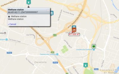
Points of interest (POIs)
Define key POIs on the tracking platform, such as warehouses, petrol stations, airports, clients, head offices and facilities, on the map.
Assign an icon to each POI for immediate visibility.
Dispatch job assignments and routes directly to the POIs, automatically monitoring arrivals, idling, departures.
Import and export POIs in GPX files or send them directly to the Garmin GPS system.
Driver identification
MyWakes allows you to identify and recognize drivers for authorised vehicle engine start up or access to the tracking platform itself.
By connecting the optional driver ID kit (comprising either an RFID driver card reader or iButton Dallas keys), you can monitor on field attendance and record the activities carried out by your drivers, technicians and salesmen.
The system can be set up to allow an engine to be unblocked only by authorized personnel, which is a fundamental aspect in the car hire business or as an added security feature (you can also set an alarm for each successful or failed authentication event).
Driver authorisation may be granted or removed at any time from the tracking platform.


Attach geo-referenced photos
When you need to document a job assignment or route, it may be useful to attach one or more images to the track in the tracking platform.
With MyWakes you can upload all the images you want and geo-reference them to see their corresponding position on the map.
If the mobile phone or camera that took the photo produces geo-referenced photos, these will be automatically positioned on the point in which they were taken.
If you use our app or our IFTTT applet to take the photo, you will automatically find the geo-referenced photo uploaded onto your latest track in the tracking platform.
Customize your maps
In MyWakes tracking platform you can upload your KML, KMZ, GPX, JPG, GeoRSS files from Google Earth to view them as map overlays when you view a track.
If you decide to overlay maps (images in jpg, png, gif formats) you can adjust the transparency of the layer so that the underlying base map remains visible.
This feature is available in both the 2D and 3D view maps.


MyWakes at Smart Mobility World 2015 the future of connected cars
The Monza Circuit hosts the future smart mobility automotive My Wakes will be at Smart Mobility World 2015 that will take place on 28 – 30 October 2015 on the renowned Monza Circuit. Three days dedicated to new technologies for automotive innovation,...
Develop your tracking applications faster with MyWakes Web API
Do you want your product to grow up adding a complete solution to locate your vehicles and don't you know how ? Take a look at our developer web site, enjoy Web API and enhance your solution. MyWakes offers a GPS location finder and recorder service that permit to...
Inserting and Creating Point of Interest (POI)
From now you can have POI on all your tracks and maps of the Pickway and Keepway devices. A POI is a point that can be of and kind of interest, like a Parking area or a Tutor, from restaurant to airports. Every user can create his own point of interest or even...
MyWakes is at Parma Fair: Salone del Camper
The Hall of the Camper From the 13 to the 21September of 2014, Wewill bepresent to the Fair of Parma “the Hall of the Camper”, Stand"HELLO CAMPING". We wait for to you with our products, in order to discover with all the functionalities.