Position and routes of your fleet always under control
Precise position and routes
Know the status of your entire fleet in real time: position and routes, distance traveled, departure, arrival and idle times for each individual vehicle.
Complete control of the situation
See if your vehicles are stationary or moving; if their engines are on or off.
With you wherever you go
Monitor the situation from any internet-connected device: computer, tablet or smartphone.
Check routes
By clicking the icon of each vehicle you can immediately view the trip that it has just taken.

Improved efficiency
Calculate the times and distances between one of your vehicles and a specific destination, while monitoring up-to-the-minute traffic information, so that you can efficiently plan your entire fleet’s job assignments always taking a look at the position and routes.
Send drivers their job assignments
Directly notify operators of their destinations,position and routes, thanks to the onboard GPS Garmin navigation system that is connected to the MyWakes GPS device, thereby cutting down task planning times.
Google Street View
Thanks to the agreement with Google, not only can you access the maps on Google Maps over a secure HTTPS connection, but you can also access the satellite images and Google Street View.
In this way you can verify the actual position and routes of each vehicle, checking for idling in specific areas, such as warehouses, parking lots, historic city centers and restaurants or checking that the vehicles are not stopped near any no-entry areas, restricted traffic areas, gates or road obstacles.


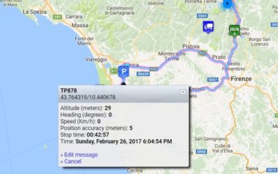
Analyze position and routes
MyWakes maps the trips that each of your vehicles has made.
You can monitor distance traveled, drive times, positions where vehicles were idle or stopped, average speeds and speeds at any point along the route.
You can view the graphs showing changes in speed and altitude over time.
Thanks to fuel level and temperature sensors, you can also view the graphs tracking the changes in these two factors.
Location history
MyWakes guarantees 12 months of data history.
Choose a track to see detailed information, including stats on speeds, altitudes, drive times; view the map or satellite image, as well as lots of other data.
You can extract position and routes information over a several day period and combine different tracks.
You can then export these routes onto GPX (GPS Exchange Format) files.

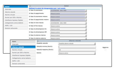
Events and actions
MyWakes provides dozens of different types of fully configurable alarms and events for the safety and security of your fleet.
You can be notified via SMS, email, phone call or by triggering an alert to a third party server via our webhooks.
Each activated alarm can provide details of the event that triggered it, such as exact time, address, vehicle licence plate, speed, etc.
Monitor situations such as the following:
- engine start-up with anti-theft system armed
- temperature in refrigerated truck is exceeded
- vehicle exits a 2D or 3D virtual boundary
- movement within an area
- vehicle is idle or stopped at POIs
- a set speed is exceeded
- position and routes
- movement with engine off (towing)
- departure from a set route
- movement of vehicle during off-hours
- excessive drop in fuel level
- engine lock/unlock
- and many more…

Odometer
Measure the distances that your vehicles have traveled in order to plan scheduled maintenance and improve fleet management, especially for long term hires.
Hour meter
For the management of heavy equipment, industrial vehicles and construction site machinery it is of upmost importance to supplement GPS data with information on running times, position and routes. MyWakes is also useful with vehicles that do not travel extensively but are still subject to wear and tear relating to hours of operation.
New sensors to detect pauses, stops and new antitheft alarm
From now on the MyWakes portal are provided new features those can be enabled on the Pickway device by putting the "anti-theft function". Among the new features is incluse the function of power on/off to PickWay.This function is used to verify the remote removal of...
Night ride “La Portaccia” starts with MyWakes GPS locators
Tracking runners The 19 July 2014 was held in Castiglione dei Pepoli (BO),a charming town of Tuscan Apennines , the second night race of the Portaccia, a circuit split into three laps for a total length of 11.2 MILES through the streets of the country. The...
New actions and alerts available on the platform
Improved functionality with the combo "Actions". With the new feature "Actions", the user can decide whether to receive alerts into or out of the virtual fence through SMS or e-mail, may decide the timing of the alarm (how often the alarm is detected), can...
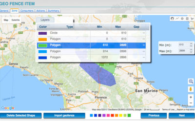
New virtual geo-fences with 3D mode and layers
3D virtual fences and layers are available. In the portal the new 3D virtual fences feature is available. Have been added the 3D virtual fences, complete with dimensions, altitude and height (useful for flight schools), alarms in and out and the new feature...