Geofence alerts: he importance of setting boundaries
Geofence alerts for vehicles
Check that your vehicles don’t deviate from the established routes raising geofence alerts.
For your loved ones
Make sure that your loved ones don’t wander outside their safe zones.
For your pets
Let your pets move freely but safely.
Three dimensional geofence alerts for your flights
Set 3D virtual geofence alerts to mark permitted flying areas.

Flexible and straightforward
Create virtual geofence alerts that are simple (circles, rectangles), complex (multi-sided polygons), composite (routes with maneuvering area) and import your completed trips as well.
Create geofences by importing a track’s GPX file
Set alarms that activate when the geofence is entered or exited
Simplify the drawing of geofences by viewing the satellite map or uploading your custom map overlays
View details of the geofence alerts that indicate the point where the virtual boundary was crossed
Set geofence alarms according to time slots and for selected users only
Use geofences to integrate IoT connected objects, such as a thermostat and house lights

3D virtual geofences
Create 3D virtual geofences to indicate no fly zones and to get geofence alerts when an aircraft is at an unauthorized altitude.

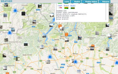
Weather forecast, conditions and cloudiness worlwide
The service displays the weather conditions and cloud cover levels around the world In the section "Utilities" you have the service to view the Weather conditions and cloud cover levels around the world on the map for quick consultation. The cloudiness will not...
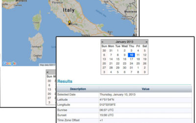
Sunrise and sunset times service worldwide
The service calculates the sunrise and sunset for the selected point and date. The service is available in the "Utilities" menu under the Sunrise / Sunset item. Select the location on Google Maps and the date on calendar. The system will automatically calculate...
The brand new GPS tracking platform is ready
The site offers services for the people, pets and objects location. The services are derived from the experience gained in the field of aviation. The tracking service allows to observe a path even in real-time. The path can remain private, to be shared with...