Make the most of tracking platform MyWakes
Document your trips
Add geo-referenced photos to the tracking platform in your tracks, find them on the map and view them at any time.
Create your POIs
Customize your maps by adding or importing points of interest.
Connect the apps
Exchange data with other apps such as Google Earth using KML, KMZ, GPX and GeoRSS data formats.
Position your maps
Create map overlays by uploading your custom maps (in jpg, gif and png formats).
 in the GPS tracking platform")
Points of interest (POIs)
Define key POIs on the tracking platform, such as warehouses, petrol stations, airports, clients, head offices and facilities, on the map.
Assign an icon to each POI for immediate visibility.
Dispatch job assignments and routes directly to the POIs, automatically monitoring arrivals, idling, departures.
Import and export POIs in GPX files or send them directly to the Garmin GPS system.
Driver identification
MyWakes allows you to identify and recognize drivers for authorised vehicle engine start up or access to the tracking platform itself.
By connecting the optional driver ID kit (comprising either an RFID driver card reader or iButton Dallas keys), you can monitor on field attendance and record the activities carried out by your drivers, technicians and salesmen.
The system can be set up to allow an engine to be unblocked only by authorized personnel, which is a fundamental aspect in the car hire business or as an added security feature (you can also set an alarm for each successful or failed authentication event).
Driver authorisation may be granted or removed at any time from the tracking platform.


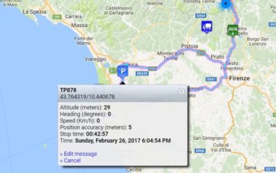
Attach geo-referenced photos
When you need to document a job assignment or route, it may be useful to attach one or more images to the track in the tracking platform.
With MyWakes you can upload all the images you want and geo-reference them to see their corresponding position on the map.
If the mobile phone or camera that took the photo produces geo-referenced photos, these will be automatically positioned on the point in which they were taken.
If you use our app or our IFTTT applet to take the photo, you will automatically find the geo-referenced photo uploaded onto your latest track in the tracking platform.
Customize your maps
In MyWakes tracking platform you can upload your KML, KMZ, GPX, JPG, GeoRSS files from Google Earth to view them as map overlays when you view a track.
If you decide to overlay maps (images in jpg, png, gif formats) you can adjust the transparency of the layer so that the underlying base map remains visible.
This feature is available in both the 2D and 3D view maps.

New sensors to detect pauses, stops and new antitheft alarm
From now on the MyWakes portal are provided new features those can be enabled on the Pickway device by putting the "anti-theft function". Among the new features is incluse the function of power on/off to PickWay.This function is used to verify the remote removal of...
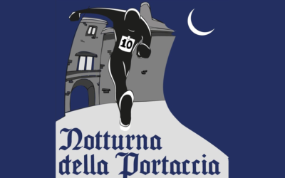
Night ride “La Portaccia” starts with MyWakes GPS locators
Tracking runners The 19 July 2014 was held in Castiglione dei Pepoli (BO),a charming town of Tuscan Apennines , the second night race of the Portaccia, a circuit split into three laps for a total length of 11.2 MILES through the streets of the country. The...
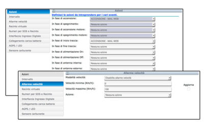
New actions and alerts available on the platform
Improved functionality with the combo "Actions". With the new feature "Actions", the user can decide whether to receive alerts into or out of the virtual fence through SMS or e-mail, may decide the timing of the alarm (how often the alarm is detected), can...
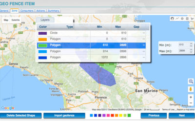
New virtual geo-fences with 3D mode and layers
3D virtual fences and layers are available. In the portal the new 3D virtual fences feature is available. Have been added the 3D virtual fences, complete with dimensions, altitude and height (useful for flight schools), alarms in and out and the new feature...