Avioportolano chart integration
MyWakes integrates Avioportolano flight charts and overlays the map with the tracks of your flights.
MyWakes increases flight tracking services thanks to the new connection between its GPS flight tracker system and the Avioportolano maps – reference for aeronautical cartography – which is now fully integrated into MyWakes.
You will get flight maps at Avioportolano digital chart site use them in your profile simply by entering the code that will be emailed to you when you purchase them.
This way you will be able to review your flights and plan your new flight plan using the Avioportolano charts as a base..
The purchased charts will be available in all MyWakes maps: both GPS tracker radar, track viewer and Rest Web API Iframe for developer will show users’ charts.
So, all third-party software that integrates MyWakes Rest interface will automatically inherit Avioportolano’s cartography support.
MyWakes is at Parma Fair: Salone del Camper
The Hall of the Camper From the 13 to the 21September of 2014, Wewill bepresent to the Fair of Parma “the Hall of the Camper”, Stand"HELLO CAMPING". We wait for to you with our products, in order to discover with all the functionalities.
New sensors to detect pauses, stops and new antitheft alarm
From now on the MyWakes portal are provided new features those can be enabled on the Pickway device by putting the "anti-theft function". Among the new features is incluse the function of power on/off to PickWay.This function is used to verify the remote removal of...

Night ride “La Portaccia” starts with MyWakes GPS locators
Tracking runners The 19 July 2014 was held in Castiglione dei Pepoli (BO),a charming town of Tuscan Apennines , the second night race of the Portaccia, a circuit split into three laps for a total length of 11.2 MILES through the streets of the country. The...
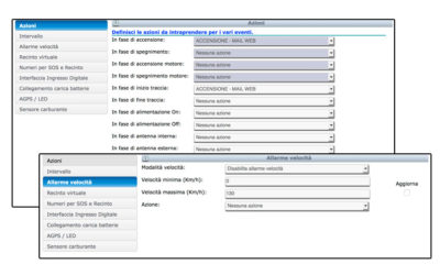
New actions and alerts available on the platform
Improved functionality with the combo "Actions". With the new feature "Actions", the user can decide whether to receive alerts into or out of the virtual fence through SMS or e-mail, may decide the timing of the alarm (how often the alarm is detected), can...
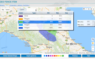
New virtual geo-fences with 3D mode and layers
3D virtual fences and layers are available. In the portal the new 3D virtual fences feature is available. Have been added the 3D virtual fences, complete with dimensions, altitude and height (useful for flight schools), alarms in and out and the new feature...
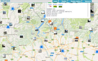
Weather forecast, conditions and cloudiness worlwide
The service displays the weather conditions and cloud cover levels around the world In the section "Utilities" you have the service to view the Weather conditions and cloud cover levels around the world on the map for quick consultation. The cloudiness will not...